
Air Traffic Management (ATM) consists of three layers of air traffic control services.

The first Air Traffic Control Center originated at Newark Airport, Newark, New Jersey, as a privately operated venture formed by cooperative airline companies in October 1935. On July 8, 1936 the Department of Commerce’s Civil Aeronautical Administration assumed operation of the air traffic responsibilities.
ARTCCs, usually referred to as “Centers,” are established primarily to provide Air Traffic Service to aircraft operating on IFR flight plans within the controlled airspace, and principally during the en route phase of flight. There are 21 Air Route Traffic Control Centers (ARTCC)in the United States. Any aircraft operating under Instrument Flight Rules (IFR) within the confines of an ARTCC’s airspace is controlled by air traffic controllers at the Center. This includes all sorts of different types of aircraft: privately owned single engine aircraft, commuter airlines, military jets and commercial airlines.
The Federal Aviation Administration has made a long-term investment of tax dollars by providing the finest air traffic control service in the world. The largest component of the national airspace system is the Air Route Traffic Control Center (ARTCC). Each ARTCC covers thousands of square miles encompassing all or part of several states. ARTCCs are built to ensure safe and expeditious air travel. All Centers operate 7 days a week, 24 hours a day and employ a combination of several hundred Air Traffic Control Specialists, Electronic Technicians, Computer System Specialists, Environmental Support Specialists, and administrative staff.
En Route control is handled by pinpointing aircraft positions through the use of flight progress strips. These strips are pieces of printed paper containing pertinent information extracted from the pilot’s flight plan. These strips are printed 20 minutes prior to an aircraft reaching each Center’s sector. A flight progress strip tells the controller everything needed to direct that aircraft. If the flight progress strips of each aircraft approaching a sector are arranged properly, it is possible to determine potential conflicts long before the aircraft are even visible on the Center controller’s display. In areas where radar coverage is not available, this is the sole means of separating aircraft.
The strips, one for each en route point from which the pilot will report his/her position, are posted on a slotted board in front of the air traffic controller. At a glance, he/she is able to see certain vital data: the type of airplane and who is flying it (airline, business, private, or military pilot), aircraft registration number or flight number, route, speed, altitude, airway designation,and the estimated time of arrival at destination. As the pilot calls in the aircraft’s position and time at a predetermined location, the strips are removed from their slots and filed. Any change from the original flight plan is noted on the strips as the flight continues. Thus, from a quick study of the flight progress board, a controller can assess the overall traffic situation and can avoid possible conflicts.
| There are 20 centers in the continental United States. All centers are identified by a three letter identifier that starts with ‘Z’. ZOA stands for Oakland Center, the ARTCC that provides en route services over our airspace in northern California. | 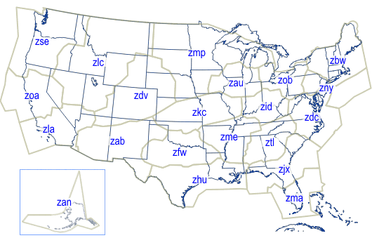
|
There are 3 En Route Centers adjacent to Oakload Center, and Oakland Center also manages the Pacific Oceanic airpsace. In addition, there are many ATC Towers and radar approach control facilities that work directly with Oakland Center.
Oakland Center’s airspace is split up into smaller, manageable pieces of airspace called “sectors”. Sectors have vertical as well as horizontal boundaries. A few sectors extend from the ground up, but most areas are stratified into various levels to accommodate a wide variety of traffic. Each sector has a unique radio frequency that the controller uses to communicate with the pilots. As aircraft transition from one sector to another, they are instructed to change to the frequency of the next sector. Oakland Center’s airspace is broken down into high altitude and low altitude sectors. |
|


From one to three controllers may work a sector, depending upon the traffic density. Each controller is assigned to work the positions within an area of specialization. Controllers have direct communication with pilots, with surrounding sectors and Centers, plus the Towers and Flight Service Stations under their jurisdiction. Each control position is equipped with computer input and readout devices for aircraft flight plan data.
In general there are 3 basic controller positions working together to monitor and direct traffic within the Center’s airspace.
Radar Controller
This controller is in charge of the sector. This controller maintains positive separation among all aircraft under his/her control. Separation standards from a Center are defined as 5 miles laterally or longitudinally for aircraft flying at the same altitude, or 1,000 feet vertical separation below 29,000 feet and 2,000 feet vertical separation above 29,000 feet. The radar controller is responsible for all air-to-ground communications. Coordination with other sectors and facilities is a duty shared by both the radar controller and the associate controller.
Associate Controller
The radar associate controller assists the radar controller and receives flight plan information on aircraft anywhere from 5 to 30 minutes in advance of aircraft entering the sector. The associate controller works with the radar controller to plan separation of aircraft and to coordinate with other sectors and facilities.
Radar Hand-off
This controller assists the radar team when air traffic becomes very heavy. The hand-off controller serves as another set of eyes to maintain separation of aircraft and coordinate with other controllers and facilities as necessary. This extra help also serves to maintain a smooth and efficient flow of air traffic.
Controllers in each Center work at a console that displays the radar data, allowing controllers to see the aircraft within their airspace. The display consists of various lines, letters, numbers and symbols that aid the controllers. The sector boundaries show the lateral limits ofthe sectors. Circles denote the location of ground based navigation stations. Lines extend outward from these navigation stations showing the location of airways. Aircraft are represented on the display as slashes.
Each aircraft has a data block associated with it that gives the controller important information.

The first line of the data block shows the aircraft’s call sign. The second line shows its altitude. If there are two numbers on this line, the aircraft is either climbing or descending. The first number of these 2 numbers shows the assigned altitude with the second of the 2 numbers displaying the aircraft’s actual altitude. An arrow indicates if the aircraft is climbing or descending. The third line of the data block contains two primary pieces of information. The first three numbers show the aircraft’s Computer ID number (CID). The controller uses this number frequently to update information associated with this aircraft. If the controller needs to change some information about this aircraft, he/she can use this CID rather than a lengthier call sign. The other numbers on the third line show the aircraft’s speed across the ground.
The Center controllers have many decision support tools (computer software programs) that provide vital information to assist the controllers in maintaining safe separation distances for all aircraft flying through their sector. One such predictive tool allows the controller to display the extended route of any aircraft on the radar screen. One such route is called a “vector line.” This line projects where the aircraft will be within a specified number of minutes, assuming the aircraft does not change its course. This is a helpful tool to determine if aircraft flying intersecting routes will pass safely within the separation standard, or if they will conflict with each other.
In addition to vector lines, the controller can also display a “route line” for any given aircraft on his/her radar screen. This will tell the controller where a particular aircraft will be in specified number of minutes as well as the path the aircraft will fly to get there. Decision support tools such as these help each controller look ahead and avoid conflicts.

TRACON (Terminal Radar Approach Control) are facilities containing radar operations from which air traffic controllers direct aircraft during the departure, descent and approach phases of flight. One TRACON can handle the air traffic for several different airports in its sector. The airspace of a TRACON has various dimensions depending upon its location within the US, and the size and number of airports it serves. Dallas-Fort Worth TRACON, for example, monitors the airspace from 17,000 feet and below, at a radius of approximately 40 miles from the DFW airport.
The TRACON controllers direct aircraft that are transitioning from the en route phase through to the approach phase into a destination airport located within the TRACON’s airspace. There is more than one controller position in the TRACON. These positions are designated as follows:
- high altitude descent controller
- low altitude descent controller
- approach controller
- feeder controller
Typically a series of TRACON controllers direct an aircraft through 2 stages of descent (high altitude to low altitude). The high altitude controller will hand off the aircraft to the low altitude controller who then hands off the aircraft to the approach controller. The approach controller merges the many descending aircraft flying toward the same destination airport into one line of air traffic maintaining safe separation. When the aircraft reach about 50 miles outside the destination airport the approach controller performs an electronic transfer and hands the aircraft off to the Feeder Controller. Once the arriving aircraft are within the airport’s airspace, they are handed off to the Local Controller located in the airport’s control tower. The aircraft are then no longer being monitored by the controller’s in the TRACON.
TRACONs also control an aircraft that is transitioning after takeoff to the departure phase until the flight is handed off to the Air Route Traffic Control Center (ARTCC) for its en route phase. The Departure Controller in the TRACON routes the ascending aircraft immediately upon takeoff via a preferential departure route (PDR) leading away from the departure airport.
There are 185 TRACON facilities in the United States. TRACONs are usually located as separate facilities from airports. There are typically more than 3 TRACONs within a Center’s airspace. In some locations within the US, TRACONs handle traffic for only a single major airport. These TRACONS are then located in the Air Traffic Control Tower of that airport. TRACONs in areas servicing several major airports like the Northern California TRACON and Potomac TRACON in the Washington, DC area are often located off airport grounds. Combining TRACON facilities in many areas should enhance operational efficiency. Multiple-airport TRACONs can cover several hundreds of square miles. A large TRACON facility could have 40 or more controllers working multiple sectors around several airports.

Currently, the Northern California region is served by four major airports:
- San Francisco International Airport
- Oakland International Airport
- San Jose International Airport
- Sacramento International Airport
Each TRACON has responsibility for controlling specifically defined and limited sections of “airspace.” That responsibility involves ensuring that all aircraft entering or departing the airspace are kept separated at safe distances. When necessary TRACONs reroute aircraft to avoid dangerous weather patterns. A TRACON’s total airspace is subdivided into small sections called “sectors.” Each sector is assigned to an individual air traffic controller who works in the TRACON facility.
The TRACON controller directs the movement of aircraft in and out of that airspace by monitoring a radar screen and maintaining voice contact with pilots. Although the controller’s individual responsibility is only for his or her own sector, all controllers within a TRACON have full radar information on all the aircraft that are under control of the entire TRACON facility. In addition, these controllers are able to communicate with one another instantly- something that contributes significantly to assuring the safety of aircraft passengers.
By contrast, in a control environment such as that which exists within this region today, controllers in one TRACON have limited ability to communicate with controllers in adjacent TRACONs. This is true even though aircraft will pass from the airspace controlled by one TRACON into that of another. “Hand-offs” (the electronic transfer of control and separation responsibility between TRACONs) are routine within the Northern California. To assure the safety of such hand-offs today aircraft in this region often must use longer routes than would be necessary in a single TRACON. In other words, some efficiency is sacrificed to safety concerns, as it should be in a system that puts safety first.
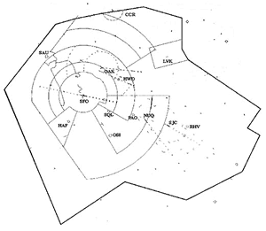
TRACON jurisdictions are not the same as Class “B” or Class “C” airspace. For example, compare the Bay Area Class “B” airspace and the Bay TRACON airspace shown below.

|
|
Tower

Control towers were established to provide for a safe, orderly, and expeditious flow of air traffic at an airport and in its vicinity. It is hard to miss the Control Tower, the tall building with the glass-enclosed cab on top. Each airport’s control tower is also known as Local Control.
There are four major controller classifications at control towers:
- Flight Data Controller
- Clearance Delivery Controller
- Ground Controller
- Local Controller
Controllers working in an airport’s control tower are rotated through each position during one work shift. Each of these positions has specific duties.
Flight Data (FD) Controller
The Flight Data Controller:
- Receives and relays IFR Departure clearances
- Operates the Flight Data Processing Equipment
- Relays weather and NOT AM Information
Previously, the FD Controller managed in-range flights using “flight progress strips” of paper. Today, the paper strips have been effectively eliminated with electronic flight data displays (the User Request Evaluation Tool – URET).
The Flight Data Controller is also responsible for the Automatic Terminal Information Service (ATIS) equipment. ATIS recordings are made every hour or more often if the weather changes.
Clearance Delivery Controller
The Clearance Delivery Controller is responsible for obtaining and relaying departure clearances to pilots.
These departure clearances include the following information:
- Aircraft Identification
- Clearance limit
- Departure Procedure
- Route of flight
- Altitude assigned
- Departure frequency
- Transponder code
The Clearance Delivery Controller checks to see that the route indicated for the flight requested conforms to established preferential routes. If there are departure restrictions that would supersede the requested clearance, then the clearance delivery controller may temporarily amend the clearance.
>strong>Ground Controller
The Ground Controller is responsible for the ground movement of aircraft taxiing or vehicles operating on taxiways or inactive runways. The ground controller is responsible for and can issue clearances only to those aircraft and vehicles that can be seen by this controller.
Runway Incursion prevention is a primary responsibility of the ground controller. In the year 2000 there were more than 400 runway incursions recorded. A runway incursion is the unauthorized entry of an aircraft or vehicle onto an active runway without the permission of the local controller.
For a Ground Controller to issue a clearance for an aircraft or vehicle to cross an active runway, the ground controller must first gain permission from the local controller responsible for that runway.
Another major responsibility for the ground controller is protection of “critical areas”. These protected zones include localizer, glide slope and precision approach critical areas. The critical areas provide greater obstacle clearance during approaches. As the weather conditions change the size of the zone increases. For example, if the weather conditions give a ceiling of less than 800 feet with the landing aircraft between the outer marker and the runway, then taxiing aircraft and other ground vehicles must hold short of the designated critical areas until the aircraft has landed.
For approaches by “heavies” with the ceiling less than 200 feet or with the Runway Visual Range (RVR) at 2,000 feet or less, the critical area expands to an even greater distance from the runway. The airport is responsible for determining size of the critical area and designating the affected runways and/or taxiways in their briefings.
Local Controller
The one major responsibility of the Local Controller is to provide separation between arriving and departing aircraft. Another major responsibility of the Local Controller is to safely sequence arrivals and departures. This controller also relays IFR clearances and taxi instructions. The Local Controller also issues takeoff and landing clearances and provides assistance to other flights flying through their local area.
Of course, there are regulations. The FAA has clearly identified guidelines for keeping aircraft at a safe distance from each other. This is known as safe separation distance. According to the FARs, runway separation regulations describe the following 3 aircraft categories
- Category I – light-weight single-engine propeller driven aircraft
- Category II – light-weight twin-engine aircraft weighing 12,500 pounds or less
- Category III – everything else including high performance single-engine propeller airplanes, large multi-engine propeller aircraft and all turbine powered aircraft
The FAA separation regulations also specify that departing aircraft may not take off from a runway unless:
- A landing aircraft has taxied clear of the runway, or
- A departing aircraft is airborne and is clear of the departure end of the runway or
- A departing aircraft has turned away from the departing runway
But the regulations also say that the following aircraft can depart:
- If the takeoff separation is 3,000 feet and both aircraft are Category I
- If a Category II aircraft departs before a Category I aircraft
- If a Category II aircraft takes off after a Category I aircraft
- If both aircraft are Category II aircraft and the separation distance is 4,500 feet If either aircraft is a Category III aircraft and the separation distance is 6,000 feet
In other words, during the Takeoff phase of flight a fast, large jetliner should never take off behind a much smaller and slower 2-seater aircraft until it is out of the way. A local controller can allow an aircraft in line for takeoff to “taxi in position and hold” on the runway while another aircraft is on its takeoff roll.
For arriving aircraft similar separation standards apply. IFR flights use a standard instrument approach when arriving at an airport. VFR pilots follow a standard traffic pattern. The VFR traffic pattern is an established, standardized flight pattern.
The separation regulations for arriving aircraft are similar to the departure regulations with added complications. Arriving aircraft have different speeds with higher speed aircraft overtaking other slower aircraft. Many aircraft have stall speeds higher than many other aircraft top speeds. The controllers must sequence and space all arriving aircraft in a dynamic system.
A further complication is all aircraft produce wingtip vortices. Vortices are caused by the generation of lift from the wings. The vortices generated by a small aircraft are not nearly as troublesome as the vortices generated by a “heavy”. “Heavy aircraft” (aircraft weighing 255,000 pounds or more) and Boeing 757 aircraft, generate vortices with a strength of small tornadoes. Wingtip vortices generated by a large jetliner can cause tremendous turbulence for a much smaller aircraft if it is following too close behind. There has to be a greater separation in distance and time when a “heavy” is in the traffic mix. Wingtip vortices can cause problems no matter the size of any of the aircraft if safe separation is not maintained.
Remember, it is the local controller who determines the spacing and separation of both departing and landing aircraft. Wingtip vortices and safe separation are extremely important to the pilots of these aircraft and the local controller assisting them.
