
Objective: In this unit, you will spend time flying a short cross country flight from French Valley to Hemet-Ryan to develop your ability to identify landmarks and enter the traffic pattern and land at an uncontrolled airport.
Completion Standards: You have completed this unit when you can fly to and find Hemet-Ryan airport without getting lost, enter the traffic pattern correctly, and land safely.
Preparation:
-
Use the Los Angeles Sectional and a plotter (or SkyVector) to determine the magnetic course and distance from French Valley (F70) to Hemet-Ryan (KHMT).
-
Determine the appropriate VFR cruising altitude for the flight. Click here for a reminder on how to apply the VFR cruising altitude rule..
-
Determine a checkpoint to help you keep the aircraft on your selected course.
-
Determine the amount of time it will take to fly from F70 to KHMT
-
Determine when you will descend (top of descent).
-
Determine the traffic pattern entry route.
- Research Hemet-Ryan Airport (KHMT) and create a diagram for entering and flying the traffic pattern that includes heading and altitudes.
Radio Phraseology
In this lesson, you will self-announce position and intention information on the French Valley CTAF as you takeoff and depart the area, and on the Hemet-Ryan CTAF as you arrive and land. Each of these self-announce transmissions will use the same familiar format:
Who you are talking to – Who you are – Where you are – What are your intentions
To depart French Valley, you would normally make three self-announcements on the French Valley CTAF.
- Taxi:
French Valley Traffic, Cessna 123AB is taxiing from the ramp to runway 36, French Valley. - Takeoff:
French Valley Traffic, Cessna 123AB is departing runway 23, straight out departure, French Valley. - Departing the area:
French Valley Traffic, Cessna 123AB is upwind of runway 36, climbing through 2,500, French Valley.
Once you are clear of the French Valley area (5-10 NM), switch over to the Hemet-Ryan AWOS and obtain the one-minute weather. Then switch over to the Hemet-Ryan CTAF and monitor it for a few moments to determine if other aircraft are operating at the airport and which runway they are using.
- 5 NM Out:
Hemet-Ryan Traffic, Cessna 123AB is 5 miles to the southwest at 3000 feet, Hemet-Ryan. - 45 Leg:
Hemet-Ryan Traffic, Cessna 123AB is entering the 45 for runway 23, Hemet-Ryan. - Downwind Leg:
Hemet-Ryan Traffic, Cessna 123AB is entering left downwind for runway 23, Hemet-Ryan. - Base Leg:
Hemet-Ryan Traffic, Cessna 123AB is turning left base runway 23, Hemet-Ryan. - Final Leg:
Hemet-Ryan Traffic, Cessna 123AB is turning final runway 23, full stop, Hemet-Ryan. - Clear of Runway:
Hemet-Ryan Traffic, Cessna 123AB is clear of runway 23, taxiing to the ramp, Hemet-Ryan.
Reference: AIM 4-1-9. Traffic Advisory Practices at Airports Without Operating Control Towers
Airspace
Class G Airspace
Uncontrolled airspace or Class G airspace is the portion of the airspace that has not been designated as Class A, B, C, D, or E. It is therefore designated uncontrolled airspace. Class G airspace extends from the surface to the base of the overlying Class E airspace. Although ATC has no authority or responsibility to control air traffic, pilots should remember there are visual flight rules (VFR) minimums which apply to Class G airspace.
Remember: Class G always starts at the surface, except when some other type of airspace extends to the surface, and is always overlaid by Class E airspace.
Most uncontrolled airports without a precision instrument approach are in Class G airspace. No ATC facility provides service at the airport, thus no controlled airspace is required.
Class E Airspace
The most populous type of airspace is Class E airspace, or controlled airspace. The primary purpose of Class E airspace is to protect IFR (instrument flight rules) aircraft by providing separation from other IFR aircraft. VFR aircraft should always be providing their own separation from other VFR and IFR aircraft by only flying in visibility and with cloud clearances that will allow you to ‘see and avoid’ other aircraft.
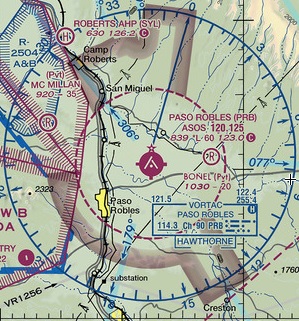
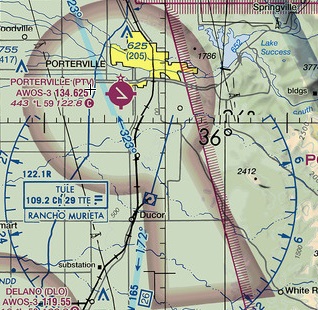
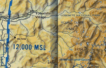
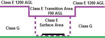
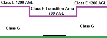
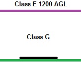
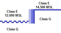
Typically, Class E airspace starts at 1,200 AGL. The exceptions are for airports that have an instrument approach where Class E will start at the surface or 700 AGL, and the mountains where Class E will start at a specified MSL or 14,500 ft MSL.
| Class E Starts at Surface | Class E Starts at 700 AGL | Class E Starts at 1200 AGL | Class E Starts at Specified MSL | Class E Starts at 14,500 MSL |
 |
 |
Soft side of shaded blue |
 |
Hard side of shaded blue |
 |
 |

|
 |
|
| Uncontrolled airport with a precision instrument approach | Uncontrolled airport with a non-precision instrument approach | Uncontrolled airport without an instrument approach | Mountainous terrain, but controlled airspace needed below 14,500 for enroute flight | Mountainous terrain |
|
 |
 |
 |
|
VFR Weather Minimums in Class E and G Airspace
Just as the purpose of airspace is to protect IFR aircraft, the purpose of VFR weather minimums is to protect IFR aircraft from VFR aircraft. If you recall where IFR aircraft are likely to be operating based upon the class of airspace, it will become easier to associate the required VFR minimums.
Controlled Airspace below 10,000 MSL – aka Class E Airspace
Standard IFR separation between aircraft is three miles, and thus the standard VFR visibility requirement is 3 miles, which if met should allow a VFR aircraft to ‘see and avoid’ an IFR aircraft.
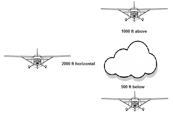
IFR aircraft, especially airliners and turboprops climb at steep gradients (typically 2000-4000 FPM). If a jet is climbing through a cloud, and then pops out, it will not be able to see aircraft that are not visible underneath its nose. This is why VFR minimums in controlled airspace require you to be at least 1,000 above clouds.
However, when descending, most aircraft descend at a much slower rate (500-2000 FPM), and the low nose angle allows a descending aircraft to see what is ahead when descending out of a cloud, thus the cloud clearance below clouds is only 500 ft.
Horizontally, VFR cloud clearance is at least 2000 ft. If an aircraft is in cruise flight below 10,000 ft, it’s speed is limited to 250 knots indicated airspeed (which depending on altitude, could mean a true airspeed as high as 300 knots. Assuming an aircraft was flying at 250 knots true airspeed, and popped out of cloud, its moving at 422 ft per second – 2000 ft will be covered in less than 5 seconds. How quick are your reactions?
You can more easily remember the VFR visibility and cloud clearance requirements as 3-152s, as in three Cessna 152s (3 mile visibility, 1000 ft above clouds, 500 ft below clouds, and 2000 ft horizontal).
Uncontrolled airspace below 10,000 MSL
Class G airspace permits a lower visibility requirement and cloud clearance requirement as IFR aircraft typically do not operate in Class G airspace (although it is legal and possible).
- Below 1,200 AGL: 1 SM visibility and clear of clouds
- Above 1,200 AGL, but below 10,000 MSL: 1 SM visibility and 1,000 ft above, 500 ft below, 2,000 ft horizontal from clouds.
However, at night, Class G airspace has the same visibility and cloud clearance requirements as Class E: 3-152s.
Airspace Above 10,000 MSL
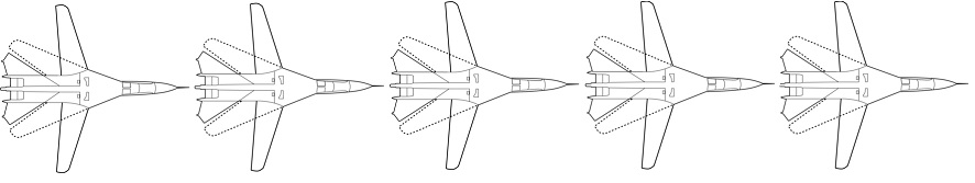
Above 10,000 MSL, the 250 knot speed restriction does not apply, and thus the visibility and cloud clearance requirements increase in both controlled (Class E) and uncontrolled airspace (Class G) to 5 SM visibility and 1,000 ft above, 1,000 ft below, and 1 SM horizontal from clouds. You can more easily remember this as five F-111s. The F-111 was a figher-bomber used by the Air Force during the Vietnam conflict. A unique, and thus memorable aspect of the F-111, is that featured a variable-sweep wing.
Airspace Requirements and Services
Class G, being uncontrolled airspace, and Class E, controlled airspace but the most populous type of airspace and not associated with a tower controlled airport, has no equipment and communication requirements, unless you are above 10,000 MSL and 2,500 AGL, in which case a Mode C transponder is needed. This is because at this altitude, there are likely to be enroute IFR aircraft. ATC needs the Mode C transponder readout to provide separation for IFR aircraft. In Class E and G airspace, ATC may provide traffic advisories on a workload permitting basis.
| Equipment Requirement | Entry Requirement | ATC Services |
| There is no equipment requirement (radio or transponder) when operating in Class E or G airspace, except when above 10,000 MSL and 2,500 AGL a Mode C transponder is required. | There is no ATC entry requirement to enter Class E and G airspace. | In Class E and G airspace, the only VFR service provided by ATC is traffic advisories. |
Airspace/Airport Review:
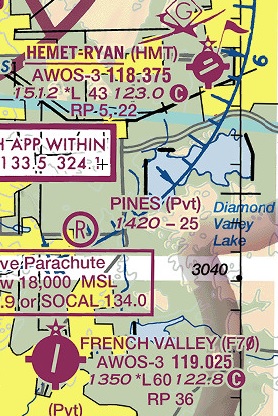
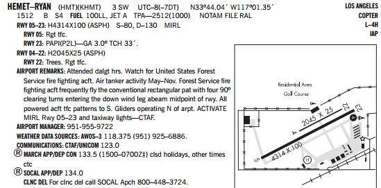
Examine French Valley and Hemet-Ryan airports on the Los Angeles Sectional chart and in the Southwest US Airport/Facility Directory and answer these questions below.
Hover over the question to check your answer. If you were not correct, please reference the resources below:
Resources – Aeronautical Chart User Guide – Airspace Summary
|
|
Weather
You will obtain the AWOS at French Valley prior to taxiing, and the AWOS at Hemet-Ryan as you approach the airport. When you are arriving an airport, you want to be able to write down the AWOS in one loop. Practice doing this Hemet-Ryan’s AWOS phone at (951)-925-6886 (obtained from A/FD).
Once you have obtained your destination airport AWOS, analyze it.
- The wind information will help you select the most favorable runway, and help you predetermine crab angles needed on the downwind, base and final legs.
- The ceiling and visibility information will help you identify if the weather is above VFR and your personal minimums.
- The temperature and dewpoint information will help you identify if conditions are conducive for fog, or if high density altitude conditions are likely.
- The local altimeter setting will help ensure you are at the same TPA as other aircraft and set up your pattern for a good approach and landing. Be sure to reset your altimeter after obtaining your destination AWOS.
Aviation weather products use abbreviations to communicate a lot of information in a small format. You can study this guide to interpret METAR and AWOS report.
Setup
- Console: Ensure Panel Master switch is on, throttle is at idle and mixture is rich.
- Launch Microsoft Flight Simulator.
- Select ‘Cessna 172 – F70 – Northwest Ramp’ flight file.
- Print and review this airport diagram to determine the aircraft’s position on the runway and route to taxi to the runway.
Experience Checklist
- Obtain the AWOS in the simulator; enter the F70 AWOS into the Comm 1 radio and switch it to the active frequency. Practice writing down the AWOS as fast as it is heard. Determine the runway to be used based upon the reported winds.
- Enter the F70 CTAF frequency into the Comm 1 Radio.
- Broadcast the taxi announcement on the CTAF.
- Taxi to runway that is best aligned into the wind.
- Complete the runup and before takeoff checks.
- Perform a collision avoidance scan to ensure the runway is clear at all air and ground incursion points.
- Make departure announcement and enter runway
- Takeoff and after reaching 1,000 AGL turn on course to Hemet-Ryan airport.
- Verify your checkpoint is in front of the aircraft and keep it there as you fly to Hemet-Ryan.
- Level off at your cruise altitude.
- Obtain the Hemet-Ryan AWOS and prepare for arrival.
- Switch over to the Hemet-Ryan CTAF and announce your position.
- Verify you have Hemet-Ryan airport in sight and descend for Hemet-Ryan.
- Make all announcements in the traffic pattern (5 NM out, 45, downwind, base, final, clear of runway).
- If you are having trouble obtaining alignment with the runway when turning final, use the heading indicator to determine a heading to fly back to the airport. If you lose complete sight of the airport, reset the simulator and start again.
Reflection
Reflect on what was needed to fly between two uncontrolled airports. Write down notes and questions on the experience bring to your next lesson with your instructor.
- Did you find your checkpoint?
- Did you find Hemet-Ryan airport?
- Were you able to enter the pattern at Hemet-Ryan and land successfully?
