
Objective: In this unit, you will develop the knowledge and skill to obtain traffic advisories from an ATC radar controller for a short cross country flight between two uncontrolled airports.
Completion Standards: You have completed this unit when you can:
- Depart an uncontrolled airport and obtain traffic advisories from ATC.
- Fly to your destination airport.
- Discontinue ATC radar service and land at your destination airport.
Preparation:
-
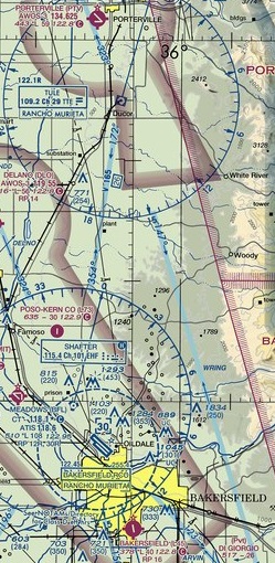
Use the Los Angeles Sectional and a plotter (or SkyVector) to determine the magnetic course and distance from Porterville (KPTV) to Bakersfield Municipal (L45).
-
Determine the appropriate VFR cruising altitude for the flight. Click here for a reminder on how to apply the VFR cruising altitude rule..
-
Determine checkpoints to help you keep the aircraft on your selected course.
-
Determine the amount of time it will take to fly from KPTV to L45.
-
Determine when you will descend (top of descent). Expect that ATC will instruct you to remain clear of the Bakersfield Meadows Class Delta, so you’ll need to plan your descent to avoid this airspace.
-
Determine the traffic pattern entry route.
Radio Phraseology
ATC facilities with radar equipment are able to provide you with information regarding other aircraft that are operating near enough to you aircraft to warrant your attention. This service is known as traffic advisories, and is available to VFR aircraft on a workload permitting basis. Traffic advisories are available from most ATC facilities, including:
- Tower – some towers are equipped with a BRITE radar scope that enables a tower controller to issue traffic advisories.
- Approach and Departure Control – this level of ATC exists around Class C and B airports to provide separation between arriving and departing IFR aircraft.
- Center – this level of ATC provides IFR separation between airports, and in the flight levels (above 18,000 ft), which is typically referred to as the enroute structure.
A typical traffic advisory sounds like:
Traffic, 1 o'clock, 5 miles, same altitude, westbound.
Traffic means another aircraft, bearing of the traffic relative to your track is given using the 12 hour clock, distance in nautical miles, altitude is the Mode C readout from the other aircraft, and direction of the aircraft is inferred from their radar track. If the type of aircraft is known, that will be included in the advisory.
Note that the bearing to the traffic is given based upon your track (which is known from radar), not your heading (which is not known). If you are flying a wind corrected heading, you will need to consider that angle in relation to the clock azimuth given to you by the controller in order to more easily locate the traffic.
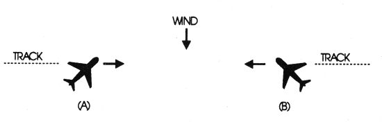
Example – Traffic information would be issued to the pilot of aircraft “A” as 12 o’clock. The actual position of the traffic as seen by the pilot of aircraft “A” would be 2 o’clock. Traffic information issued to aircraft “B” would also be given as 12 o’clock, but in this case, the pilot of “B” would see the traffic at 10 o’clock.
Source: AIM Figure 4-1-1
When given a traffic advisory, you will acknowledge differently depending if you see the traffic.
Traffic in Sight conveys that you see the traffic and will maintain visual separation.
Negative Contact conveys that you do not see the traffic and will continue to look until you do. If the controller has time, and it appears that your flight paths will continue to merge, the controller may issue you a second traffic advisory to help you locate the aircraft.
If you were unable to find the traffic that ATC pointed out, you may hear the controller say:
Traffic No Factor– Indicates that the traffic described in a previously issued traffic advisory is no factor.Traffic No Longer Observed– Indicates that the traffic described in a previously issued traffic advisory is no longer depicted on radar, but may still be a factor.
Vectors and Altitude Restrictions
Controllers may also use vectors and altitude restrictions to help separate you from traffic. Here are examples of these instructions.
Maintain 4,500 for traffic
Maintain at or above 4,500 for traffic
Maintain at or below 4,500 traffic
Turn left 20 degrees for traffic
With each of these ATC instructions, you need to readback the entire instruction and comply with the instruction (14 CFR 91.123). Note that a controller is supposed to give you the reason for a vector or altitude restriction, in this case traffic. As soon as you have identified the traffic and report Traffic in sight, the controller will typically respond with:
Altitude pilot's discretionorAltitude restriction cancelled– you can fly at any desired altitude consistent with the VFR cruising altitude rule.Resume own navigation– you can resume flying your desired course.
Safety Alert
If the controller believes that your aircraft and another aircraft not in communication with ATC are in unsafe proximity to each other, the controller may issue you a traffic alert with an instruction to maneuver either by turning, climbing or descending to avoid the traffic.
Skyhawk 123AB, traffic alert, traffic 2 o'clock, 1 mile, advise you climb 500 feet immediately.
Items to remember when using the ATC traffic advisory service
- You are never relieved of your responsibility to ‘see and avoid’ other traffic.
- The controller is at all time prioritizing IFR operations. The controller may not issue you a traffic alert, even if a collision is likely, if higher priority IFR operations are in progress.
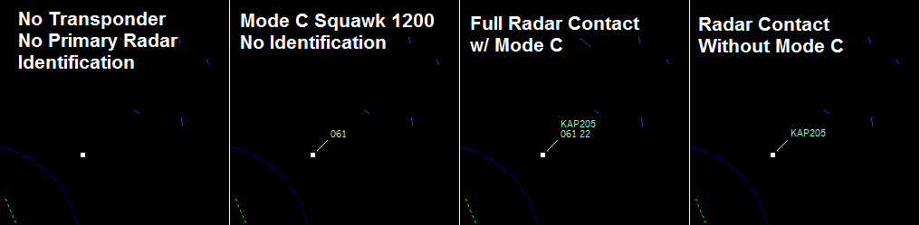
- Aircraft that are not equipped with a Mode C transponder are not transmitting altitude to the ATC secondary surveillance radar, and thus the controller will not know their altitude, only position and track.
- Monitor the ATC frequency until service is discontinued. If you are approaching your destination and wish to discontinue the service, request a frequency change. If your destination is a tower controlled airport, the controller will hand you off to the tower when appropriate.
- You’ve asked for advisories, and the controller will provide them as they occur. You need to keep a constant vigil to listen for your callsign.
References: 4-1-15. Radar Traffic Information Service
Transponder Operation

Aircraft with operating transponders help improve the safety of the National Airspace System by providing ATC’s secondary surveillance radar system with additional information such as the type of aircraft, i.e. 1200 equals a VFR aircraft, and altitude. The secondary surveillance radar system is not a typical radar that ‘bounces’ radio waves off reflective aircraft, but instead ‘interrogates’ transponders. An operating Mode C transponder is typically required to obtain traffic advisories from ATC.
While certain types of airspace require a Mode C transponder (Class E above 10,000 MSL while above 2,500 AGL, Class C and above Class C, Class B and 30 NM around Class B airport AKA Mode C Veil), if an aircraft is equipped with a transponder it should be used in all types of airspace. The transponder should be turned to ALT mode prior to movement on the surface, and not turned off until the flight has completed.
Transponders typically have a mode selector switch or buttons. OFF is self explanatory. The ‘SBY’ position is used to keep the transponder warmed up, but not transmitting. Transponders and their encoders typically require a few minutes to warm up before they can begin transmitting altitude information. The ‘ON’ position corresponds to Mode A, transmitting only the squawk code. The ‘ALT’ position transmits both Mode A and Mode C, which includes the aircraft’s pressure altitude in 100 ft increments (altitude corresponding to standard pressure, 29.92 in). The ‘TEST’ position is only used by avionic technicians.
The Mode A squawk code, also referred to as a beacon code, is selected either by turning a knob associated with each of the four positions available, or by punching buttons to set the code. Some newer transponders also have a ‘VFR’ button that will set the ‘1200’ code quicker. As a VFR aircraft, you will always have ‘1200’ set in the transponder, unless assigned a discrete code by ATC, or you need to squawk an emergency code.
Transponders are equipped also equipped with an IDENT button. When pressed, an extra data bit is included in the transmission, and on the controller’s scope, the word ID or IDENT will temporary be displayed on that aircraft’s data tag. Transponders typically also have an interrogation light or display a symbol or letter (typically R) when being interrogated by ATC radar or another aircraft’s traffic collision avoidance system (TCAS(.
Controllers will issue you instructions regarding the operation of your transponder
SQUAWK (number). Operate radar beacon transponder on designated code.IDENT. Engage the “IDENT” feature of the transponder.SQUAWK (number) and IDENT. Operate transponder on specified code engage the “IDENT” feature.SQUAWK STANDBY. Switch transponder to standby position.SQUAWK ALTITUDE. Activate Mode C with automatic altitude reporting.STOP ALTITUDE SQUAWK. Turn off Mode C.STOP SQUAWK. Switch off transponder.SQUAWK MAYDAY. Squawk code 7700.SQUAWK VFR. Squawk code 1200.
Reference: AIM 4-1-20 Transponder Operation
Here are examples of what a controller sees depending on the transponder mode and operational state.
Obtaining Traffic Advisories
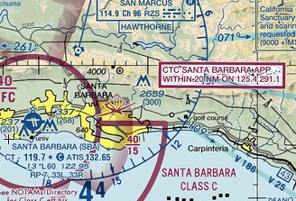
To obtain traffic advisories, you first need to determine the ATC facility and frequency for the airspace you are operating in. If you are operating near a Class C, Class B or TRSA, an airspace information boxes will be located around the airspace, with instructions to contact the controlling agency. In this case, pilot’s are encouraged to contact Santa Barbara Approach when operating with 20 NM of Santa Barbara Municipal.
When operating at airports not in proximity to Class C and B airspace, research that airport’s Airport/Facility Directory (A/FD) entry.
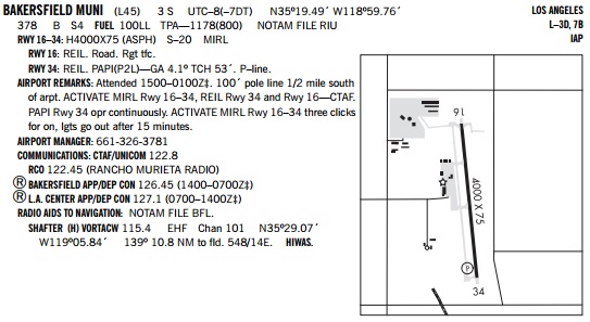
In the Communications section, look for the ‘circle R’ symbol, or the words App/Dep Con. In the case of the Porterville AFD entry below, Bakerfield App/Dep Control is available from 0600-2300 PST, and Los Angeles Center is available when Bakersfield Approach is closed.

With the facility name and frequency in hand, we can contact ATC to request traffic advisories. ATC needs four bits of information from a pilot in order to be able to provide traffic advisories.
- Callsign of aircraft
- Type of aircraft
- Location
- Destination
Here’s an example initial call-up to Bakerfield Approach to request traffic advisories.
Bakersfield Approach, Cessna 123AB is a Cessna 172, 3 miles south of Porterville, request traffic advisories to Bakersfield Municipal, Lima 45.
The radar controller will respond with:
Cessna 123AB, Bakerfield Approach, Squawk 4214.
You will readback the squawk code and set the code in your transponder.
After about 30 seconds and workload permitting, you will hear:
Cessna 123AB is radar contact 5 miles south of Porterville. Bakersfield altimeter 30.12. Say Altitude.
Let’s analyze this transmission.
radar contact– ATC has identified your aircraft and will provide traffic advisory service.5 miles south of Porterville– your location on the radar scope; it should match where you think you are.Bakerfield altimeter 30.12– all aircraft receiving radar service from ATC need to use the same altimeter setting to ensure indicated altitude is consistent with current pressure.Say Altitude– the controller wants to verify that your indicated altitude matches the corrected Mode C altitude from your aircraft transponder displayed on the controller’s scope.
You would respond:
Cessna 123AB, level at 4,500.
If you were climbing or descending at the time of the request, you would respond with your current altitude, rounded to the nearest 100 ft and the altitude you are climbing or descending to.
Cessna 123AB, 2,300 climbing 4,500.
After verifying that your Mode C readout matches your indicated altitude, you can expect to hear only three types of further transmissions:
- Traffic advisories
- Hand-off to another sector or destination
- Radar service termination
We’ve covered traffic advisories earlier, we’ll cover service termination last, let’s cover hand-offs now.
Hand-offs
As you progress through your flight, you’ll fly through multiple ATC sectors. The controller/frequency you are currently using will instruct you to contact a new controller on a new frequency when you are approaching the boundaries between the sectors.
Cessna 123AB, contact Los Angeles Center on 127.1
You would readback this instruction, configure 127.1 in the active frequency on your radio, and call-up the new controller.
Los Angeles Center, Cessna 123AB, level 4,500, VFR to Bakersfield Municipal
Again, when you check on with a new controller, provide your altitude to allow the controller to verify your Mode C altitude. Also, if the hand-off is to a different ATC facility (Bakersfield Approach vs Los Angeles Center) you should also include your destination in case there is no automated hand-off between facilities and your destination is not automatically available to the new controller.
Discontinuing Traffic Advisories
As you approach your uncontrolled airport destination, you will want to switch to the CTAF to start monitoring and making announcements. Before you can switch frequencies, you’ll need to terminate radar service. Controllers will typically terminate service automatically once you are about 10 miles from your destination, but occasionally their workload will prevent them from doing this. You can always request service termination by stating:
Cessna 123AB, Bakersfield Municipal in sight, cancel traffic advisories.
Whether you requested it, or the controller proactively cancels service, you will hear:
Cessna 123AB, no traffic observed between you and Bakersfield Municipal, radar service terminated, Squawk VFR, Frequency changed approved.
Radar service terminated– ATC is no longer providing you traffic advisory service.Squawk VFR– set code 1200 in the transponderFrequency change approved– you can change to your destination CTAF frequency.
Airspace
Special Use Airspace
Military Operation Areas (MOAs) exist to designated areas in which military aircraft train. Inside the MOAs, military aircraft may practice formation flying, aerial refueling, tactical maneuvers and aerobatics, and fly in excess of 250 knots. At night, military aircraft may fly ‘lights out’ in an MOA, making it impossible for you to see their aircraft.
VFR aircraft are permitted to fly through MOAs without requesting permission, but obviously flight in an MOA means a riskier flight. All MOAs will have a controlling agency that you can contact to determine if the MOA is active (‘hot’) and if you must fly through an active MOA, traffic advisories are a must to reduce risk.
Let’s look at the Hunter Low A and Hunter High MOA off the coast of central California.

MOAs typically do not start at the surface, but do typically extend up to, but do not include, FL 180.

Looking at the MOA table on the top of the backside of the sectional chart, Hunter High MOA extends from 11,000 MSL up to, but not including FL 180. Hunter Low A MOA extends from 200 AGL up to, but not including, 11,000 MSL. This vertical slicing of the airspace provides greater flexibility for the military to only activate a small portion of airspace. Oakland Center is the controlling agency, and each MOA has a different frequency to contact as the High MOA is a high altitude sector, and the Low A MOA is a low altitude sector. As both MOAs time of use is ‘Intermittent by NOTAM’ there’s a good chance that they will not be active when you desire to fly through them. Oakland Center will know if the MOAs are active; you can also check NOTAMs for the airspace before flight.
Airspace/Airport Review:
Examine Porterville (KPTV) and Bakersfield Municipal (L45) airports on the Los Angeles Sectional chart and Southwest US A/FD and answer these question below.
Hover over the question to check your answer. If you were not correct, please references the resources below
Resources – Aeronautical Chart User Guide – Airspace Summary
|
|
Weather
Obtain the METAR for Porterville and the METAR and TAF for Bakersfield Meadows at http://www.aviationweather.gov.
Aviation weather products use abbreviations to communicate a lot of information in a small format. You can study this guide to interpret METAR and AWOS report.
Setup
- Console: Ensure Panel Master switch is on, throttle is at idle and mixture is rich.
- Launch Microsoft Flight Simulator.
- Select ‘Cessna 172 – KPTV – Southwest Ramp’ flight file.
- Print and review this airport diagram to determine the aircraft’s position on the runway and route to taxi to the runway.
- Launch PilotEdge and connect to the PilotEdge network.
Experience Checklist
- Obtain the Porterville AWOS in the simulator; enter the Porterville AWOS into the Comm 1 radio and switch it to the active frequency. Determine the runway to be used based upon the reported winds.
- Enter the Porterville CTAF into the Comm 1 Radio, make a taxi announcement and taxi to the runway.
- Perform run-up, review your cross country flight plan, and enter Bakersfield Approach (120.5 Mhz) into the standby frequency of the Comm 1 radio.
- Perform collision avoidance scan, make a takeoff announcement and enter the runway for departure.
- After departing the traffic pattern, turn on course and continue to climb to your cruise altitude.
- Identify your preselected checkpoints.
- When approximately 3 miles from Porterville, switch frequencies to Bakersfield approach.
- Contact Bakersfield Approach and request traffic advisories to Bakersfield Muni. Its likely that the controller will think you mean Bakersfield Meadows, so also include the identifier for Bakersfield Muni, L45.
- Continue to fly your plan, identify your checkpoints, and respond to ATC traffic advisories.
- Descend for Bakerfield Muni, cancel traffic advisories, switch the Bakersfield Muni CTAF and make self-announcements.
- Enter the traffic pattern, make all self-announcements, land and exit the runway.
Reflection
Reflect on the sequences of communication needed to obtain traffic advisories from ATC.
