
Objective: In this unit, you will develop the knowledge and skill to obtain a taxi clearance and a takeoff clearance for departure at a tower controlled airport, and an initial call-up, pattern entry and landing clearance at a different towered controlled airport.
Completion Standards: You have completed this unit when you can:
- Obtain a taxi and takeoff clearance at your departure airport.
- Fly to you your destination airport.
- Obtain a landing clearance at your destination airport.
Preparation:
-
Use the Los Angeles Sectional and a plotter (or SkyVector) to determine the magnetic course and distance from Santa Maria (KSMX) to San Luis Obispo (KSBP).
-
Determine the appropriate VFR cruising altitude for the flight. Click here for a reminder on how to apply the VFR cruising altitude rule..
-
Determine a checkpoint to help you keep the aircraft on your selected course.
-
Determine the amount of time it will take to fly from KSMX to KSBP.
-
Determine when you will descend (top of descent).
-
Determine the traffic pattern entry route.
Radio Phraseology
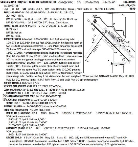
In this lesson, you will obtain the ATIS on the ground at Santa Maria, review the airport diagram to determine the most efficient route from your current position to the active runway, and request a taxi clearance.
Santa Maria Ground, Cessna 123AB, transient parking southeast of the terminal, ready to taxi with information Tango.
If runway 30 was in use, you would hear:
Cessna 123AB, Santa Maria Ground, taxi to runway 30 via Alpha, Alpha Seven.
You would read this taxi clearance back, taxi, complete your run-up, and call the tower for a takeoff clearance.
Santa Maria Tower, Cessna 123AB, holding short runway 30, northwest departure.
You would hear:
Cessna 123AB, Santa Maria Tower, cleared for takeoff runway 30, straight out departure approved.
Readback this takeoff clearance, perform a collision avoidance scan, enter the runway and depart for San Luis Obispo.
When you are clear of Santa Maria’s airspace, you can change frequencies. If you need to change frequencies while within the lateral or vertical dimensions of the airspace, request frequency change approval from the tower by stating:
Cessna 123AB requests frequency change.
Once you are established on your on course heading and cruise altitude towards San Luis Obispo, prepare for arrival.
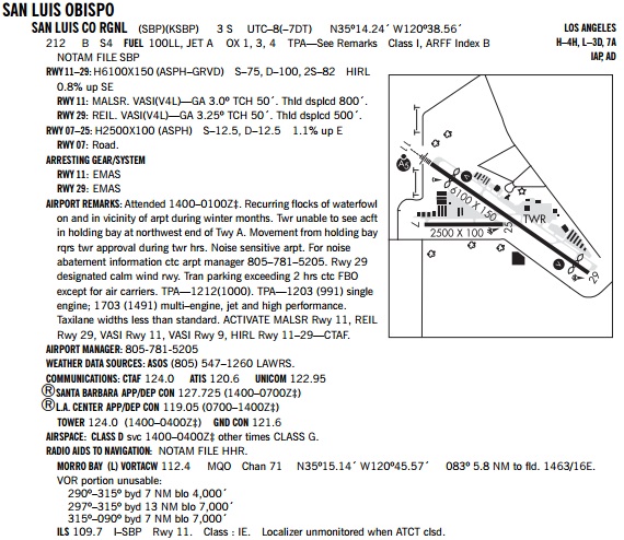
Obtain San Luis Obpiso’s ATIS and then monitor San Luis Obispo’s tower frequency to determine aircraft operations in progress.
When 10 NM from San Luis Obispo, call up the tower:
San Luis Obispo Tower, Cessna 123AB is 10 miles to the southwest at 4,500 ft, full stop landing with information Zulu.
If runway 29 is in use, you will likely hear:
Cessna 123AB, San Luis Obispo Tower, make straight in runway 29, report 3 miles.
Readback this pattern entry instruction, maneuver and descend for a straight in approach to runway 29. Use the visual glide slope indicator on runway 29 to maintain a safe rate of descent, and slow down your final approach speed prior to reaching 1000 AGL.
Report your position to the tower when on a three mile final. The tower uses this position report as a prompt to issue you a landing clearance or other instructions if necessary due to other traffic.
Cessna 123AB, three mile final, runway 29, full stop.
You will hear:
Cessna 123AB, cleared to land runway 29.
Readback this landing clearance, land, exit at the first available taxiway and cross the hold short line and stop. After a few moments the tower will either state:
Cessna 123AB Say Parking in which case you would respond with ‘transient parking’.
or
Cessna 123AB contact ground when off in which case you would state ‘Cessna 123AB contact ground’, call up ground with your current position and parking destination, and readback the assigned taxi instructions.
Note that if the tower issues you a taxi clearance they may also instruct you to ‘Remain this frequency’ which means continue to monitor the tower frequency while taxiing. This occurs when one person is working both the tower and ground positions in the cab. If you are instructed to ‘Monitor ground’ then switch to the ground frequency.
Airspace
Special Use Airspace
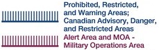
Special use airspace (SUA) is airspace designated for activities that need to be confined to a limited area to protect aircraft that are not part of the activities. Most special use airspace protects military training activities and weapons testing.
Most SUA is indicated by a lines that has small perpendicular in the interior border. We’ll discuss each of these types of airspace as we encounter it so that you understand the activities that take place in each. However, a good rule of thumb is that if the SUA is indicated by a magenta border, permission is not required to enter the airspace, but traffic advisories are recommended. If the SUA is indicated by a blue border, permission from ATC is required to enter (technically, Warning areas do not require permission).
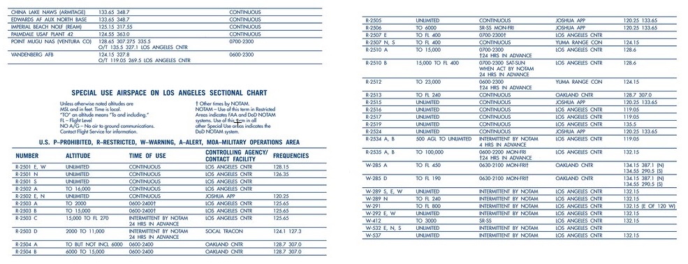
All SUA has an identifier to help you look up information regarding the dimensions of the airspace, time in use and the controlling agency. You can look up the SUA in the Special Use Airspace table at the top border of the back side of the sectional chart for the airspace that includes the SUA. You can also check to see if there are NOTAMs for the airspace, typically indicating the times of operation, when you obtain a weather briefing.
Restricted Airspace
Activities that are hazardous to nonparticipating aircraft occur in restricted areas. Typical activities include military live-fire exercises and weapons testing, but there other activities.
Some restricted areas are only active at specified times, and when inactive VFR aircraft can enter the airspace without permission, and IFR aircraft can be routed through the airspace. When restricted ares are active, VFR aircraft cannot enter, and IFR aircraft will be routed around the airspace.
Restricted airspace is identified by the blue SUA border and a ‘R’ airspace identifier.

Take for example R-2513, a restricted area near the coast of central California.
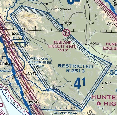
The chart conveys the lateral boundaries, but we need to look at the table to understand the vertical boundary and times of use.

Typically, restricted areas start at the surface, and that’s the case for R-2513 where altitude indicated is ‘To FL 240’ which indicates the ceiling is up to and including FL 240. The time of use of this airspace is continuous, which makes it unlikely we’d be able to fly through this airspace VFR. But, we can always check. Oakland Center, on 128.7 Mhz, is the controlling agency and we can check with them to see if the airspace is active.
Airspace/Airport Review:
Examine Santa Maria and San Luis Obispo airports on the Los Angeles Sectional chart and Southwest US A/FD and answer these question below.
Hover over the question to check your answer. If you were not correct, please references the resources below
Resources – Aeronautical Chart User Guide – Airspace Summary
|
|
Weather
Obtain the METAR for both Santa Maria and San Luis Obispo using http://www.aviationweather.gov/metar.
Aviation weather products use abbreviations to communicate a lot of information in a small format. You can study this guide to interpret METAR and AWOS report.
Setup
- Console: Ensure Panel Master switch is on, throttle is at idle and mixture is rich.
- Launch Microsoft Flight Simulator.
- Select ‘Cessna 172 – KSMX – East Ramp’ flight file.
- Print and review this airport diagram to determine the aircraft’s position on the runway and route to taxi to the runway.
- Launch PilotEdge and connect to the PilotEdge network.
Experience Checklist
- Obtain the Santa Maria ATIS in the simulator; enter the KSMX ATIS into the Comm 1 radio and switch it to the active frequency. Determine the runway to be used based upon the reported winds.
- Enter the Santa Maria ground frequency into the Comm 1 Radio and request a taxi clearance. Remember to include the current ATIS identifier in your transmission.
- Readback the taxi clearance and taxi to the assigned runway.
- Perform run-up, tune in Santa Maria tower and request a takeoff clearance.
- Readback takeoff clearance, perform collision avoidance scan and enter the runway for departure.
- After departing the traffic pattern, turn on course and continue to climb to your cruise altitude.
- Identify your preselected checkpoints.
- Obtain the San Luis Obispo ATIS and then monitor tower. When 10 miles out from KSBP, call the tower with your position, intentions and ATIS identifier.
- Readback and comply with the pattern entry instructions from the tower.
- Report your position to the tower and obtain your landing clearance. Readback the clearance.
- Perform a landing, taxi off the runway at the first available taxiway, and wait for tower to ask for parking or switch you over to ground.
- Taxi as assigned, monitor tower or ground as assigned, and when in the transient parking area, end the simulator session.
Reflection
Reflect on the sequences of communication needed to depart and arrive at a tower controlled airport.
